
Hi,
It is municipal election day, and for the first time since 1988 it is an holiday. Some refer to those elections as the option to chose who will be bribed as your mayor for the next 5 years. We used it for a nice morning hike, just like we used the last election day for a tour in Atlit concentration camp.
This time we choose Nahal Taninim Nature reserve (means Crocodile stream in Hebrew) which is last clean salty stream still run in Israel Coastal Plain. Most of the stream water are captured for use. But the salted springs feeding it are no good as drinking water and left to flow to the sea.
The name comes from the crocodiles lived here. They were brought here for the Roman gladiator wars in Ceaseria , or naturally lived here as part of the flora. The last one was captured in 1912, and presented in Ernest Schmitz collection in Tel Aviv University.
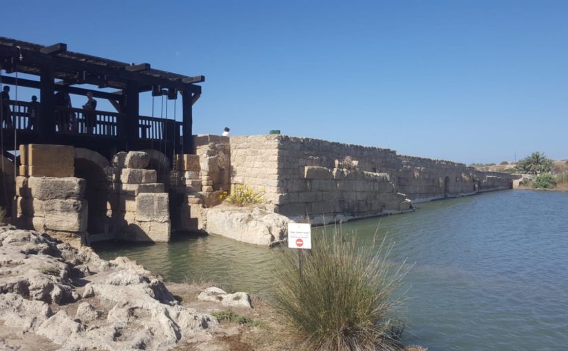
What you see on site (and of course interesting me 😃) are the remains of a dam used to hold the stream water and run it to Ceaseria on an aqueduct (the second one constructed). The dam based on natural Kurkar ridges that run along Israel Mediterranean sea shore. The ridges closed the flow of streams to the Mediterranean sea making swamps that made first Israeli pioneers an hard time. Not only the dam is based on the natural topography of the area, it still stand after thousands of year. Making me admire the Roman engineers 😃
The dam includes routing tunnels, water regulatory device, deviation pools and flour mills.
My Chaco sandals tore apart 😕. Just like in hike in Ein Gedi in 2015, it happened hiking with same friends. Only now those friends are married with 2 kids 😃. Apparently Chaco stopped using Vibram sole. that was the main reason I bought my first pair. I hoped they will hold better than the Source sandals I used to have to have, and managed to tear pretty fast. With Vibram sole the Chaco holds around 3 years for me and I hope the new one, with Chaco sole, will last at least as much 😁.
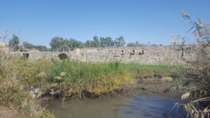
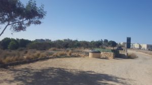 The site sits next to Jiser A-Zarka (“Blue beach”) an undeveloped Arab village
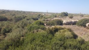
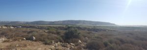 In the distance the you can see Mount Carmel and its edge
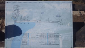 A map of the dam and it parts.
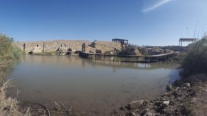
 The Dam and the small lake behind it. The dam was constructed during the 3-4 centuries BC.
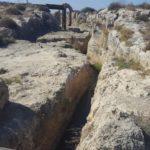
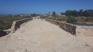
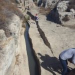
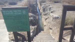 Part of the aqueduct. A short water train can be done in it (260 m long), keep in mind it is only 80cm wide and the water height are about 40cm. It full length was 7 km and it provided 2,500 cubic meters of water per an hour to ceaseria.
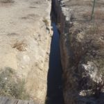
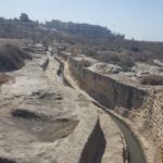
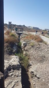 The lower aqueduct part that was abandoned due the error in engineering.
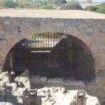
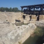
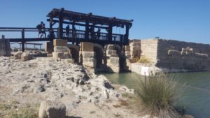 The Dam water regulatory device arches. The device regulated the water to the aqueduct. During the Byzantine period a tunnel was dug to led the water to the flour mills.
 The arches and the dam
More of the aqueduct in which you can walk. In the left pic you can see the valuated roof (here it is about 3 m high) that covered the entire length of the aqueduct.
 Roman stone quarry and the pipe factory. Kabra swamp, created behind the dam, was drained between 1922 and 1923. Baron the Rothschild established a clay pipe factory on a land he had purchased in order to develop the area. The pipes were supposed to be used to drain the pipe, but the manufacture was unsuccessful and pipe were imported from France instead. A network or pipes, 50 km in total, were used to drain the 6,000 dunam swamp and to cap 5,000 springs and flow their water into an outlet channel.
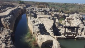
The other side of the water regulatory device: consists three deep passages (the arches in the dam), a higher one and a distribution pool. To control the amount of water three wooden slats were installed in the exit from the passages.
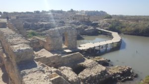
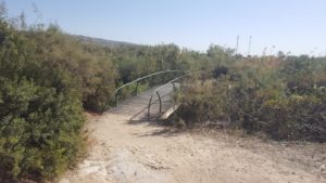
A passageway over the water – small trail let you go and over this small pool and back up to the dam.
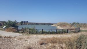
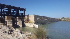
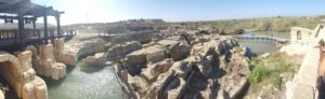
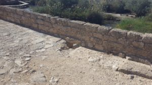
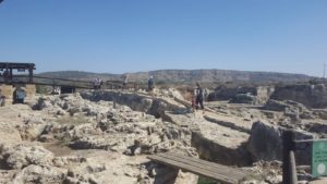
The dam – 194m long and 4-10 meter width used to hold the water of Nahal Taninim. Today it is of course a lot lower.
The lake created was 6.5m high (in Roman or Byzantine periods) and 4.5m high in the Ottoman time
 Drainage opening in top of the dam. Elementary isn’t it? In Israel until the 1990’s bridges weren’t drainage wasn’t designed….
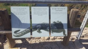 A sign on the bridge bringing a quote about a crocodile in Nahal Taninim 1877.
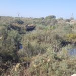
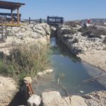
Nahal Ada (“Ada Stream”) going through the dam and joining here to Nahal Taninim
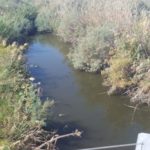
The stream of Nahal Taninim going through the dam and on the the sea.
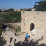
A renovated flour mill from ottoman time in the edge of the bridge. Similar to the one in 7 mills site.
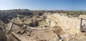
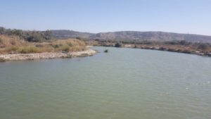
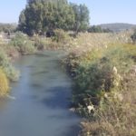
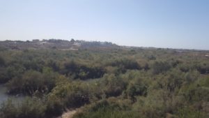 The view from the panorama on the edge of the dam. The stream is the last clean salty stream on coastal plain. The water comes from Timsah springs (“Crocodylidae spring”), and keeping it clean allows to the flora here to prosper and let you understand how various and wide it was in Israel.
 The rest of the small trail is among Atriplex (“Salty” in Hebrew). You are crossing Nahal Taninim and Nahal Ada back.
 The dam from below
 The small trail over the water from below
The low aqueduct. The small path in it ends here. The aqueduct goes all the way to Ceaseria.
Another look over the regulator water device
 Atzva and Jannaues walking back to the dam
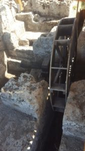 A vertical water wheel. The only in Israel from the Byzantine time.
Nahal Taninim Nature reserve – The dam trail
loading map - please wait...
Bonjour,
Vous parlez bien du site naturel se trouvant à Askelon ?
Si tel est le cas, les travaux envisagés permettront de maintenir l’eau du lac pendant toute l’année. Merci de me tenir informé si vous avez plus d’informations.
Cordialement
Hi,
It is near Jiser a Zarka which is in Northern Israel, not near Ashkelon.
Gad