
Hi,
Ayalon stream was flooded this morning.
Back in the days the highway was built, that was a big issue. In 1988, when the last part of it was open, it was the main North-South highway in Israel. When you understand how important that road was, you can understand the problem the flood caused. A single highway in that direction, in a country which its shape is long (North-South) and narrow (East-West). When we had to drive to Haifa from Jerusalem we had to go through Ayalon highway what meant to enter the most heavy traffic metropolitan area in Israel (Tel Aviv), just to pass to its other side.
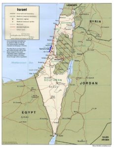 Ayalon highway (colored in blue) as part of Israel road system (Source: maps-of-the-world)
But not only the Ayalon highway was built on the banks of the stream, but also Ayalon railway in 1993 (a link to a post with a video of the development of the railway system in Israel). And train unlike the cars on roads, making alternative paths when the stream got flooded is pretty impossible (see a post of what happen when some of the trains north are canceled).
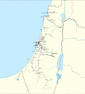 Ayalon railway (colored in red) as part of Israel railway system (Source: Wikipedia)
The Highway and the the railway were built on the banks of Ayalon stream. It was a open area back then and the stream crossed the The metropolitan area from North to South. Pretty unusual, for most of the stream in Israel flow in East-West direction.That fit the direction needed for both the highway and the railway, but meant that the stream will have to run in a concrete tunnel, that once flooded will close the road and the highway. Unlike the Yarkon stream, also crossing Tel Aviv metropolitan area but surrounded in a park.
Therefore it made sense they were designed to be flooded only one in 50 years. The only highway and railway crossing the state North-South. A flood like that during a work day can paralyze most of the working force of Israel – something you deferentially do not want to happen. Just look on idea of closing the road and the railway during a work day night (and not saturday) for a new bridge construction, and you understand the importance of the Ayalon transportation corridor.
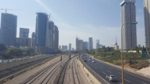 Ayalon transportation corridor: The Highway, the railway in the stream low in the trench on the left
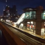
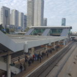
Ayalon transportation corridor: The Highway, the railway in the stream low in the concrete trench. Day and night from both sides of Tel-Aviv center train station.
The first and most long flood event occur in 1991, only 3 years after the main part of the highway was open. Apperantly the concrete tunnel was designed to be flooded once in 50 years, and to take the flow of 560 sqm/sec. But it was built only to the capacity of 300 sqm/sec, means it will get flooded more frequently. Even when the capacity enlarged to 420 sqm/sec, there are still more floods than what it was designed for. Look on the floods:
December 1991 – closed for 24 hours
October 2000 – closed for 3 hours
November 2003 – closed for 3 hours (North direction only)
January 2013 – closed for 6 hours
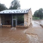
December 2018 – closed for 5 hours (Today event).
Today event was really “one in 21 years rain event”, you can see the rain maps below and the floods caused around Israel coastal plain.
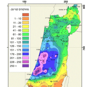 Rainfall map during the weekend (6-8.12.2018). Ayalon drainage basin in pretty much all in the blue colored area (Source: IMS)
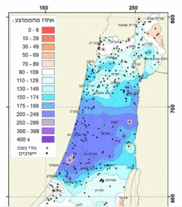 Rainfall till date in comparison to yearly average until date (6-8.12.2018). Again – Ayalon drainage basin in pretty much all in the blue colored area (Source: IMS)
The floods can be prevented, but with a large amount of money invested. The problem is that Ayalon railway is pretty much the bottleneck of Israel railway system and a fourth railway is urgently needed in there. Another 2 will probably be needed in the following years. That means a different solution is needed: either an underground tunnel directly to the sea, or to catch the stream water in lakes (what I think is better ![]() )
)
בגלל עליית מפלס המים: נתיבי איילון לכיוון דרום נחסמו לתנועה @ynetalerts pic.twitter.com/suysS71xS6
— איתי בלומנטל (@ItayBlumental) December 7, 2018
“Ayalon South Highway is closed due to flood”
החסימה בנתיבי איילון: pic.twitter.com/BiaCFtuEXL
— כאן חדשות (@kann_news) December 7, 2018
“Ayalon South Highway are closed”
ללא מילים: הצפת ענק בצומת תל נוף בכביש 40, סמוך למושב בית אלעזרי@hadasgrinberg pic.twitter.com/azxmyp1xBp
— כאן חדשות (@kann_news) December 7, 2018
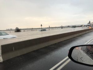 Floods in Road 40 – Ayalon drainage basin -police spokesman
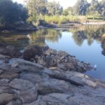
HaYarkon River at 7 mills in a quiet morning
HaYarkon River at 7 mills in the morning after the storm (Ayalon stream flow into HaYarkon, but further West of here)
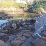
The damage in 7 mills cross of HaYrakon Stream
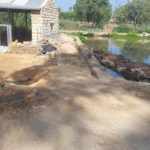

7 mills during ordinary day and during the storm (right pic source: HaAretz)
Take Care
Gad